In 2008, we were faced with the challenge of mapping Alaska, the only state with no digital orthophotos or other forms of mapping. I approached this challenge by recommending consistent statewide standards for our client and developed the Alaska DEM Whitepaper, which recommended the use of Interferometric Synthetic Aperture Radar (IFSAR). The whitepaper has served as a blueprint for mapping Alaska to National Map Accuracy Standards. In 2010, we began mapping the state, and I believe that we have risen to the occasion. Not only have we progressed past the halfway point of mapping Alaska in its entirety, but we have also determined a new elevation for Denali (formerly Mt. McKinley).

A synthetic view of Denali’s IFSAR elevation data.
Preparing to Survey Denali
At the Alaska Surveying and Mapping Conference in February 2015, I identified the need for a new GPS-survey of Denali. While IFSAR has served our mapping efforts well, it is not accurate enough to establish official elevations for mountain peaks such as Denali, the highest point in North America. In order to obtain this data, a climbing expedition needed to be formed, since helicopters are not allowed to carry people or equipment to the peak. I sought professionals who would be able to help me in this endeavor. Blaine Horner of CompassData and Tom Heinrichs of the University of Alaska Fairbanks (UAF) expressed interest in forming a GPS climbing expedition.
In mid-April, at the MAPPS and National Society of Professional Surveyors conference in Washington, D.C., I met with Blaine, who presented a plan for a four-man expedition that would cost $28,000 with additional in-kind support from UAF. I then met with Kari Craun of the U.S. Geological Survey (USGS) and Juliana Blackwell of the National Geodetic Survey (NGS) to solicit funding support. At the beginning of June, we received task orders from USGS and NGS to pay $28,000 for the GPS survey, and Dewberry immediately subcontracted with CompassData to execute the survey expedition.
A Challenging Climb
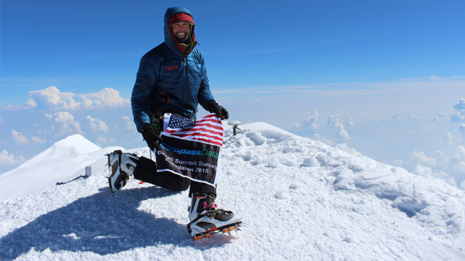
The four-man climbing team (Blaine Horner, Rhett Foster, and Udi Karriere of CompassData, plus Tom Heinrichs of UAF) flew into the Denali base camp at 7,800-feet on June 13, 2015, with 700 pounds of gear, which they carried 18 miles horizontally and 2.5 miles up under dangerous, sub-zero weather conditions with high winds. They used skis, snowshoes, and crampons to climb, while also pulling sleds with heavy equipment. On June 21, 2015, they GPS-surveyed an exposed rock at Windy Corner, and overnight from June 24-25, the team GPS-surveyed the top of the snow at two points on the peak, establishing Denali’s new, official elevation at 20,310 feet for the top of the snow on that date.
The team also determined that the snow was 4.15 meters deep (about 13 feet) at the peak before encountering resistance from ice or rock beneath. The only goal they didn’t meet was to determine the depth of snow and ice using ground penetrating radar equipment that was carried up to 17,000 feet, but did not make it to the summit because of a severe incoming storm that caused the climbers to evacuate the mountain.

Blaine Horner, survey party chief with CompassData, a Dewberry subcontractor, at the summit of Denali on June 24, 2015.
The Results
Using the latest gravity data as of 2016, the orthometric height of Denali would be 51.3 feet lower than its ellipsoid height. The last measurement of Denali was in 1989 by Jeff Yates who surveyed its ellipsoid height at 20,306 feet by using GPS. However, its official elevation was never formally published because of the lack of gravity data to convert ellipsoid heights from GPS into orthometric heights (elevations).
Before our new elevation was released, the U.S. Department of the Interior announced that the name of the mountain was being restored to its historical name of Denali; thus the mountain received both a new name and a new elevation within a seven-day period. Future plans are to seek National Park Service permission to establish a permanent survey monument at Windy Corner for additional surveys to determine whether the mountain is changing, up or down, over time. As long as the peak is covered with ice and snow, we will be unable to place an actual survey monument on the peak.
I am extremely proud to be leading Dewberry's efforts to map America's last frontier and survey our nation's most famous mountain. We are grateful to our various partners who helped us to make this happen.
DAVE MAUNE ON MAPPING ALASKA